Geolocate

Călene topographic map

Click on the map to display elevation.

About this map

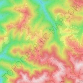
Name: Călene topographic map, elevation, terrain.

Location: Călene, Săliștea, Alba, 515603, Romania (45.81284 23.41746 45.85284 23.45746)

Average elevation: 649 m

Minimum elevation: 401 m

Maximum elevation: 831 m

Gear up for your next adventure:

🔦LED Flashlight - Powerful and long-lasting flashlight for camping and emergencies
🥾Lightweight Hiking Shoes - Comfortable shoes for day hikes
🔭Outdoor Binoculars - Lightweight binoculars for birdwatching and hiking
🔭Compact Binoculars - Lightweight optics for scouting trails and wildlife
🩹Moleskin Blister Pads - Direct protection for painful foot pressure points

As an Amazon Associate, this site earns from qualifying purchases at no extra cost to you.