Geolocate

Banner Elk topographic map

Click on the map to display elevation.

Banner Elk

Banner Elk is located in North America's humid continental climate zone due to its elevation, which gives it a climate more like that of Altoona, Pennsylvania, than Asheville, North Carolina, during the winter. During the summer the temperatures are much like a mountain lake town in New Hampshire. The town typically has cold, snowy winters and mild summers.

Wikipedia (CC-BY-SA 3.0)

About this map

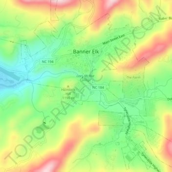
Name: Banner Elk topographic map, elevation, terrain.

Location: Banner Elk, Avery County, North Carolina, United States (36.13897 -81.88774 36.17356 -81.84810)

Average elevation: 1,164 m

Minimum elevation: 1,036 m

Maximum elevation: 1,332 m

Other topographic maps

Click on a map to view its topography, its elevation and its terrain.

Cranberry

United States > North Carolina > Avery County

Average elevation: 1,088 m

Pineola

United States > North Carolina > Avery County

Average elevation: 1,107 m

Flat Springs

United States > North Carolina > Avery County

Average elevation: 1,017 m

Linville

United States > North Carolina > Avery County

Average elevation: 1,184 m

Valley

United States > North Carolina > Avery County

Average elevation: 1,265 m

Pineola

United States > North Carolina > Avery County

Average elevation: 1,107 m

Linville

United States > North Carolina > Avery County

Average elevation: 1,184 m

Plumtree

United States > North Carolina > Avery County

Average elevation: 1,008 m

Beech Mountain

United States > North Carolina > Avery County > Beech Mountain

Beech Mountain is a mountain in the North Carolina High Country and wholly in the Pisgah National Forest. Its elevation reaches 5,506 feet (1,657 m) and generates feeder streams for the Elk River. Nestled on the top is the Town of Beech Mountain.

Average elevation: 1,433 m

Gear up for your next adventure:

🥾Trail Hiking Shoes - Durable shoes designed for rugged trails
🗺️Topographic Maps - Detailed maps to explore trails, mountains, and wilderness areas
🏃Hydration Running Vest - Carry water and maps close to your body for speed
💧Reusable Water Bottle - Durable water bottles for hydration on trails
🚲MTB Frame Bag - Carry tools and maps directly on your bicycle frame

As an Amazon Associate, this site earns from qualifying purchases at no extra cost to you.