
Cisnes topographic map
Interactive map
Click on the map to display elevation.
About this map
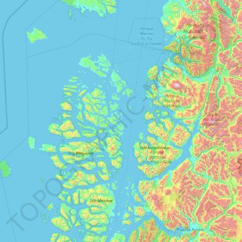
Name: Cisnes topographic map, elevation, terrain.
Average elevation: 275 m
Minimum elevation: -3 m
Maximum elevation: 2,323 m
Other topographic maps
Click on a map to view its topography, its elevation and its terrain.
Isla Clemente
Chili > Aisén du Général Carlos Ibáñez del Campo > Provincia de Aysén > Aysén
Isla Clemente, Aysén, Provincia de Aysén, Aisén du Général Carlos Ibáñez del Campo, Chili
Average elevation: 144 m
Puyuhuapi
Chili > Aisén du Général Carlos Ibáñez del Campo > Provincia de Aysén > Cisnes
Puyuhuapi, Cisnes, Provincia de Aysén, Aisén du Général Carlos Ibáñez del Campo, Chili
Average elevation: 229 m
Puerto Aguirre
Chili > Aisén du Général Carlos Ibáñez del Campo > Provincia de Aysén > Aysén > Puerto Aguirre
Puerto Aguirre, Aysén, Provincia de Aysén, Aisén du Général Carlos Ibáñez del Campo, Chili
Average elevation: 8 m
Aysén
Chili > Aisén du Général Carlos Ibáñez del Campo > Provincia de Aysén
Aysén, Provincia de Aysén, Aisén du Général Carlos Ibáñez del Campo, Chili
Average elevation: 340 m