Geolocate

Coyo topographic map

Click on the map to display elevation.

About this map

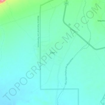
Name: Coyo topographic map, elevation, terrain.

Location: Coyo, San Pedro de Atacama, Provincia de El Loa, Antofagasta Region, 4500000, Chile (-22.97280 -68.25434 -22.93280 -68.21434)

Average elevation: 2,397 m

Minimum elevation: 2,376 m

Maximum elevation: 2,492 m

Other topographic maps

Click on a map to view its topography, its elevation and its terrain.

Laguna Lejía

Chile > Antofagasta Region > Provincia de El Loa > San Pedro de Atacama

Lejía Lake is a circular, shallow lake at an elevation of 4,325 metres (14,190 ft) with a surface area of 1.9 square kilometres (0.73 sq mi) or 2 square kilometres (0.77 sq mi). It is a polymictic lake which freezes over occasionally and whose waters are turned over quickly, mainly through evaporation. Winds…

Average elevation: 4,341 m

Atacama Large Millimeter Array Science Preserve

Chile > Antofagasta Region > Provincia de El Loa > San Pedro de Atacama

The Atacama Large Millimeter/submillimeter Array (ALMA) is an astronomical interferometer of 66 radio telescopes in the Atacama Desert of northern Chile, which observe electromagnetic radiation at millimeter and submillimeter wavelengths. The array has been constructed on the 5,000 m (16,000 ft) elevation…

Average elevation: 4,815 m

Gear up for your next adventure:

🥾Hiking Boots - Sturdy boots providing ankle support and traction on rugged trails
🛌Down Sleeping Bag - Superior warmth-to-weight ratio for cold nights
🧭GPS Tracker - Track your location in remote areas safely
🧦Hiking Socks - Moisture-wicking and comfortable socks for long hikes
Lightweight Backpacking Tent - Compact tent for efficient hiking trips

As an Amazon Associate, this site earns from qualifying purchases at no extra cost to you.