
RIO SATIPO topographic map
Interactive map
Click on the map to display elevation.
About this map
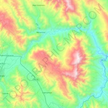
Name: RIO SATIPO topographic map, elevation, terrain.
Location: RIO SATIPO, Satipo, Provincia de Satipo, Junín, Perú (-11.26492 -74.64101 -11.16126 -74.42400)
Average elevation: 962 m
Minimum elevation: 392 m
Maximum elevation: 1,971 m
Other topographic maps
Click on a map to view its topography, its elevation and its terrain.
Plaza Mayor de Satipo
Plaza Mayor de Satipo, Satipo, Junín, Perú
Average elevation: 669 m
Plaza de Armas Santa Leonor
Plaza de Armas Santa Leonor, Satipo, Junín, Perú
Average elevation: 637 m
PLAZA DE ARMAS - JOSE OLAYA
PLAZA DE ARMAS - JOSE OLAYA, Villa Pacifico, Satipo, Provincia de Satipo, Junín, Perú
Average elevation: 681 m