Geolocate

Caney City topographic map

Click on the map to display elevation.

About this map

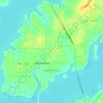
Name: Caney City topographic map, elevation, terrain.

Location: Caney City, Henderson County, Texas, United States (32.19963 -96.05106 32.22791 -96.02137)

Average elevation: 104 m

Minimum elevation: 95 m

Maximum elevation: 122 m

Other topographic maps

Click on a map to view its topography, its elevation and its terrain.

Trinity River

United States > Texas > Henderson County > Tool

Average elevation: 92 m

Murchison

United States > Texas > Henderson County

Average elevation: 146 m

Gear up for your next adventure:

💡LED Camping Lantern - Illuminate your campsite with long-lasting lanterns
🐕Hiking Dog Pack - Let your canine companion carry their own water and food
🧦Outdoor Socks - Durable socks designed for hiking and outdoor sports
🥾Waterproof Hiking Boots - Essential footwear for rugged terrain and wet Canadian trails
Bushcraft Tarp - Versatile emergency shelter or gear protection

As an Amazon Associate, this site earns from qualifying purchases at no extra cost to you.