

Fulpmes topographic map
Click on the map to display elevation.
Fulpmes
Die Stubaier Werkzeugindustrie mit ihrer bekannten Marke Stubai hat ihren Sitz bis heute in Fulpmes. Es gibt hier seit 22. August 1897 eine entsprechende Fachschule (seit 1969 Höhere Technische Bundeslehranstalt Fulpmes), welche die hohen Qualitätsstandards erhalten und ausbauen konnte.
About this map
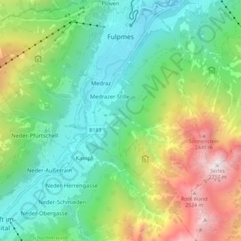
Name: Fulpmes topographic map, elevation, terrain.
Location: Fulpmes, Bezirk Innsbruck-Land, Tirol, 6166, Österreich (47.10682 11.30127 47.16111 11.38150)
Average elevation: 1,451 m
Minimum elevation: 875 m
Maximum elevation: 2,685 m
Other topographic maps
Click on a map to view its topography, its elevation and its terrain.

Nordkette
Österreich > Tirol > Bezirk Innsbruck-Land > Rum
Im Südwesten ist der Nordkette ein kleines Gebirgsmassiv vorgelagert, der Hechenberg, der mit dem Kirchbergköpfl eine Höhe von 1943 m ü. A. erreicht und nach Nordosten und Osten durch die Kranebitter Klamm von der Nordkette abgegrenzt ist.
Average elevation: 1,364 m

Lüsens
Österreich > Tirol > Bezirk Innsbruck-Land > Sankt Sigmund im Sellrain
Average elevation: 2,169 m

Sillschlucht
Österreich > Tirol > Bezirk Innsbruck-Land > Innsbruck > Sonnalm
Average elevation: 730 m

Padastertal
Österreich > Tirol > Bezirk Innsbruck-Land > Marktgemeinde Steinach am Brenner > Mauern
Average elevation: 1,747 m


Krößbach
Österreich > Tirol > Bezirk Innsbruck-Land > Neustift im Stubaital
Average elevation: 1,657 m


Laliderer Spitze
Österreich > Tirol > Bezirk Innsbruck-Land > Gemeinde Scharnitz
Average elevation: 2,004 m

Alpeiner Knotespitze
Österreich > Tirol > Bezirk Innsbruck-Land > Gemeinde Neustift im Stubaital
Average elevation: 2,791 m

Saile (Nockspitze) Vorgipfel
Österreich > Tirol > Bezirk Innsbruck-Land > Gemeinde Mutters
Average elevation: 1,903 m

Rinnenspitze
Österreich > Tirol > Bezirk Innsbruck-Land > Gemeinde Neustift im Stubaital
Average elevation: 2,666 m

Scheibe
Österreich > Tirol > Bezirk Innsbruck-Land > Gemeinde Neustift im Stubaital
Average elevation: 1,411 m

St. Margareta
Österreich > Tirol > Bezirk Innsbruck-Land > Marktgemeinde Matrei am Brenner > Waldfrieden
Average elevation: 1,312 m