
Thank you for supporting this site ❤️
Make a donation
Make a donation
Gear up for your next adventure:
As an Amazon Associate, this site earns from qualifying purchases at no extra cost to you.
Crawinkel topographic map
Click on the map to display elevation.
Thank you for supporting this site ❤️
Make a donation
Make a donation
Gear up for your next adventure:
As an Amazon Associate, this site earns from qualifying purchases at no extra cost to you.
Crawinkel
Zu Crawinkel bemerkt Galletti in seiner topographisch-historischen Beschreibung des Gothaer Herzogtums von 1780.
Thank you for supporting this site ❤️
Make a donation
Make a donation
Gear up for your next adventure:
As an Amazon Associate, this site earns from qualifying purchases at no extra cost to you.
About this map
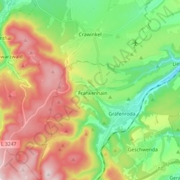
Name: Crawinkel topographic map, elevation, terrain.
Location: Crawinkel, Ohrdruf, Landkreis Gotha, Thüringen, Deutschland (50.71792 10.72425 50.79626 10.82820)
Average elevation: 536 m
Minimum elevation: 366 m
Maximum elevation: 770 m
Thank you for supporting this site ❤️
Make a donation
Make a donation
Gear up for your next adventure:
As an Amazon Associate, this site earns from qualifying purchases at no extra cost to you.