
Thank you for supporting this site ❤️
Make a donation
Make a donation
Gear up for your next adventure:
As an Amazon Associate, this site earns from qualifying purchases at no extra cost to you.
Paburia topographic map
Click on the map to display elevation.
Thank you for supporting this site ❤️
Make a donation
Make a donation
Gear up for your next adventure:
As an Amazon Associate, this site earns from qualifying purchases at no extra cost to you.
About this map
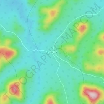
Name: Paburia topographic map, elevation, terrain.
Location: Paburia, Sarangagarh, Kandhamal, Odisha, 762112, India (20.14692 84.23531 20.18692 84.27531)
Average elevation: 700 m
Minimum elevation: 617 m
Maximum elevation: 943 m
Thank you for supporting this site ❤️
Make a donation
Make a donation
Gear up for your next adventure:
As an Amazon Associate, this site earns from qualifying purchases at no extra cost to you.