Geolocate

Hildesheim topographic map

Click on the map to display elevation.

About this map
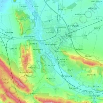
Name: Hildesheim topographic map, elevation, terrain.

Location: Hildesheim, Landkreis Hildesheim, Lower Saxony, Germany (52.09358 9.84655 52.19391 10.04280)

Average elevation: 120 m

Minimum elevation: 66 m

Maximum elevation: 298 m

Other topographic maps

Click on a map to view its topography, its elevation and its terrain.

Söhre

Germany > Lower Saxony > Landkreis Hildesheim

Average elevation: 139 m

Barienrode

Germany > Lower Saxony > Landkreis Hildesheim

Average elevation: 111 m

Mehle

Germany > Lower Saxony > Landkreis Hildesheim > Elze

Average elevation: 109 m

Gear up for your next adventure:

🛶Waterproof Dry Bags - Keep electronics and clothes dry during river crossings
🧭Orienteering Kit - Tools for map reading and navigation in the wild
🧭GPS Handheld Device - Reliable GPS navigation for outdoor adventures
👟Sport Hiking Sandals - Breathable footwear for water crossings and camp rest
🧢Outdoor Visor - Breathable visor for sunny hikes

As an Amazon Associate, this site earns from qualifying purchases at no extra cost to you.