
Thank you for supporting this site ❤️
Make a donation
Make a donation
Gear up for your next adventure:
As an Amazon Associate, this site earns from qualifying purchases at no extra cost to you.
Saarlouis topographic map
Click on the map to display elevation.
Thank you for supporting this site ❤️
Make a donation
Make a donation
Gear up for your next adventure:
As an Amazon Associate, this site earns from qualifying purchases at no extra cost to you.
About this map
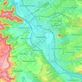
Name: Saarlouis topographic map, elevation, terrain.
Location: Saarlouis, Landkreis Saarlouis, Saarland, 66740, Germany (49.26028 6.67515 49.36206 6.81568)
Average elevation: 222 m
Minimum elevation: 169 m
Maximum elevation: 378 m
Thank you for supporting this site ❤️
Make a donation
Make a donation
Gear up for your next adventure:
As an Amazon Associate, this site earns from qualifying purchases at no extra cost to you.