
Make a donation
Gear up for your next adventure:
As an Amazon Associate, this site earns from qualifying purchases at no extra cost to you.
Rathenow topographic map
Click on the map to display elevation.
Make a donation
Gear up for your next adventure:
As an Amazon Associate, this site earns from qualifying purchases at no extra cost to you.
Rathenow
Im November 1989 kam es wie in anderen Städten der DDR zu Protestkundgebungen. Erste Treffen fanden in der evangelischen Lutherkirche statt. Anschließend sammelten sich zum Höhepunkt der Proteste rund 15.000 Menschen und zogen demonstrierend durch die Stadt zum Märkischen Platz. Es fanden mehrere Runde Tische mit Vertretern der Demonstrierenden sowie Vertretern der Stadt statt.
Make a donation
Gear up for your next adventure:
As an Amazon Associate, this site earns from qualifying purchases at no extra cost to you.
About this map
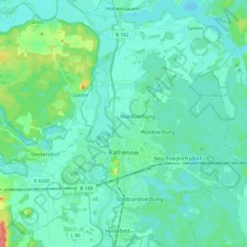
Name: Rathenow topographic map, elevation, terrain.
Location: Rathenow, Havelland, Brandenburg, 14712, Deutschland (52.56632 12.28418 52.67061 12.43091)
Average elevation: 31 m
Minimum elevation: 22 m
Maximum elevation: 76 m
Make a donation
Gear up for your next adventure:
As an Amazon Associate, this site earns from qualifying purchases at no extra cost to you.
Other topographic maps
Click on a map to view its topography, its elevation and its terrain.