Geolocate

Circleville topographic map

Click on the map to display elevation.

About this map

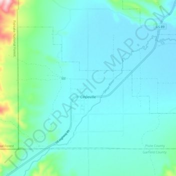
Name: Circleville topographic map, elevation, terrain.

Location: Circleville, Piute County, Utah, 84723, United States (38.14979 -112.30785 38.20079 -112.21457)

Average elevation: 1,889 m

Minimum elevation: 1,832 m

Maximum elevation: 2,233 m

Other topographic maps

Click on a map to view its topography, its elevation and its terrain.

Phonolite Hill

United States > Utah > Piute County

Average elevation: 2,098 m

Gear up for your next adventure:

🥽Outdoor Goggles - Protective eyewear for outdoor activities
🧢Hiking Hat - Sun-protective and breathable hats for long treks
🛁Quick-Dry Microfiber Towel - Space-saving towel that dries rapidly on the move
🧴Sunscreen SPF - Broad-spectrum sunscreen for outdoor activities
🧴Outdoor Sunscreen - High SPF protection for high-altitude UV exposure

As an Amazon Associate, this site earns from qualifying purchases at no extra cost to you.