
Make a donation
Gear up for your next adventure:
As an Amazon Associate, this site earns from qualifying purchases at no extra cost to you.
Strathcona Science Provincial Park topographic map
Click on the map to display elevation.
Make a donation
Gear up for your next adventure:
As an Amazon Associate, this site earns from qualifying purchases at no extra cost to you.
Strathcona Science Provincial Park
The park is situated in the North Saskatchewan River valley, on both banks of the river, at an elevation of 625 m (2,051 ft) and has a surface of 2.9 km2 (1.1 sq mi). It was established on December 12, 1979 and is maintained by Alberta Tourism, Parks and Recreation.
Make a donation
Gear up for your next adventure:
As an Amazon Associate, this site earns from qualifying purchases at no extra cost to you.
About this map
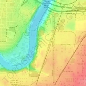
Name: Strathcona Science Provincial Park topographic map, elevation, terrain.
Average elevation: 653 m
Minimum elevation: 608 m
Maximum elevation: 691 m
Make a donation
Gear up for your next adventure:
As an Amazon Associate, this site earns from qualifying purchases at no extra cost to you.