
Make a donation
Gear up for your next adventure:
As an Amazon Associate, this site earns from qualifying purchases at no extra cost to you.
Haiming topographic map
Click on the map to display elevation.
Make a donation
Gear up for your next adventure:
As an Amazon Associate, this site earns from qualifying purchases at no extra cost to you.
Haiming
Haiming ist eine Gemeinde im Oberinntal in Tirol, Österreich, zwischen Telfs und Imst gelegen. Die Gemeinde befindet sich im Bezirk Imst (Gerichtsbezirk Silz), hat 4825 Einwohner (Stand 1. Jänner 2022) und erstreckt sich in 670 Metern Höhe über eine Fläche von 40,21 km².
Make a donation
Gear up for your next adventure:
As an Amazon Associate, this site earns from qualifying purchases at no extra cost to you.
About this map
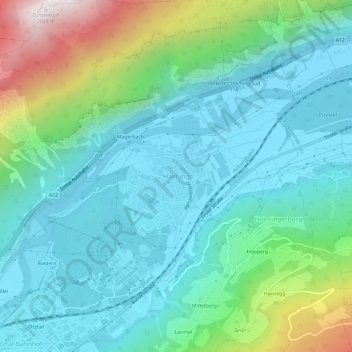
Name: Haiming topographic map, elevation, terrain.
Average elevation: 957 m
Minimum elevation: 648 m
Maximum elevation: 2,009 m
Make a donation
Gear up for your next adventure:
As an Amazon Associate, this site earns from qualifying purchases at no extra cost to you.