
Thank you for supporting this site ❤️
Make a donation
Make a donation
Gear up for your next adventure:
As an Amazon Associate, this site earns from qualifying purchases at no extra cost to you.
Złoty Stok topographic map
Click on the map to display elevation.
Thank you for supporting this site ❤️
Make a donation
Make a donation
Gear up for your next adventure:
As an Amazon Associate, this site earns from qualifying purchases at no extra cost to you.
About this map
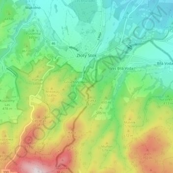
Name: Złoty Stok topographic map, elevation, terrain.
Average elevation: 458 m
Minimum elevation: 253 m
Maximum elevation: 857 m
Thank you for supporting this site ❤️
Make a donation
Make a donation
Gear up for your next adventure:
As an Amazon Associate, this site earns from qualifying purchases at no extra cost to you.
Other topographic maps
Click on a map to view its topography, its elevation and its terrain.
Węglówka
Poland > Lower Silesian Voivodeship > Ząbkowice Śląskie County > Opolnica
Average elevation: 391 m
Kopciowa
Poland > Lower Silesian Voivodeship > Ząbkowice Śląskie County > Chwalisław
Average elevation: 591 m