Geolocate

Lanas topographic map

Click on the map to display elevation.

About this map

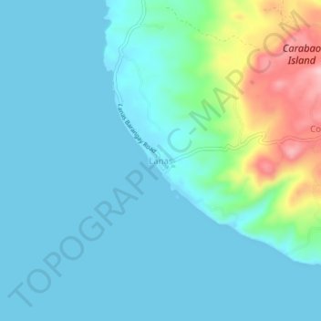
Name: Lanas topographic map, elevation, terrain.

Location: Lanas, San Jose, Romblon, Mimaropa, 5510, Philippines (12.03057 121.89819 12.07057 121.93819)

Average elevation: 35 m

Minimum elevation: 0 m

Maximum elevation: 197 m

Gear up for your next adventure:

🚲Handlebar Phone Mount - View topographic-map.com live while cycling
🦟Insect Repellent - Keep mosquitoes and black flies away in wooded areas
🧳Compression Sacks - Maximize space in your backpack by shrinking gear
🧊Portable Cooler - Keep food and drinks cold during outdoor adventures
💡Portable Camping Lamp - Rechargeable lamp for campsite lighting

As an Amazon Associate, this site earns from qualifying purchases at no extra cost to you.