
Brownsville topographic map
Interactive map
Click on the map to display elevation.
About this map
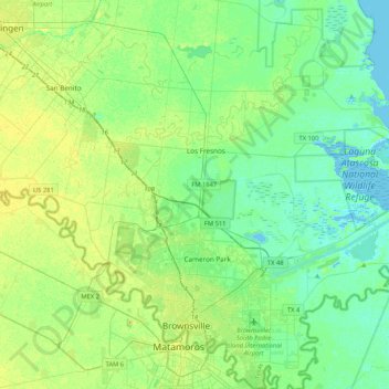
Name: Brownsville topographic map, elevation, terrain.
Average elevation: 9 m
Minimum elevation: -3 m
Maximum elevation: 25 m
Other topographic maps
Click on a map to view its topography, its elevation and its terrain.
La Feria
Vereinigte Staaten von Amerika > Texas > Cameron County
La Feria, Cameron County, Texas, 78559, Vereinigte Staaten von Amerika
Average elevation: 18 m
Rio Hondo
Vereinigte Staaten von Amerika > Texas > Cameron County > Rio Hondo
Rio Hondo, Cameron County, Texas, Vereinigte Staaten von Amerika
Average elevation: 10 m