Geolocate

Magalang topographic map

Click on the map to display elevation.

About this map

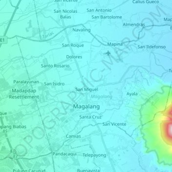
Name: Magalang topographic map, elevation, terrain.

Location: Magalang, Pampanga, Central Luzon, 2011, Philippines (15.17971 120.60641 15.27624 120.77445)

Average elevation: 69 m

Minimum elevation: -2 m

Maximum elevation: 992 m

Other topographic maps

Click on a map to view its topography, its elevation and its terrain.

Santo Rosario

Philippines > Pampanga > Magalang

Average elevation: 49 m

Manuali

Philippines > Pampanga > Porac

Average elevation: 199 m

Minalin

Philippines > Pampanga

Average elevation: 4 m

Macabebe

Philippines > Pampanga

Average elevation: 3 m

Santo Niño

Philippines > Pampanga > San Simon

Average elevation: 4 m

Masantol

Philippines > Pampanga

Average elevation: 2 m

Purok 1

Philippines > Pampanga > San Fernando > San Juan

Average elevation: 7 m

Floridablanca

Philippines > Pampanga

Average elevation: 24 m

Telabastagan

Philippines > Pampanga > San Fernando

Average elevation: 67 m

Gear up for your next adventure:

🥾Mountain Trail Shoes - High-traction shoes for mountain trails
🧼Biodegradable Camp Soap - Environmentally friendly cleaning for gear and body
🔋Lithium AA Batteries - Long-lasting power that performs in extreme cold
Camping Groundsheet - Protect your tent from moisture and dirt
🔪Outdoor Multitool - Versatile tool for repairs and food prep in the wild

As an Amazon Associate, this site earns from qualifying purchases at no extra cost to you.