
La Vattay topographic map
Interactive map
Click on the map to display elevation.
About this map
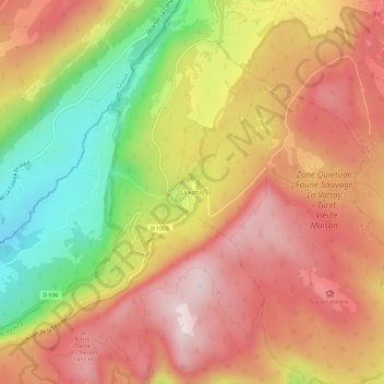
Name: La Vattay topographic map, elevation, terrain.
Average elevation: 1,294 m
Minimum elevation: 1,004 m
Maximum elevation: 1,506 m
Other topographic maps
Click on a map to view its topography, its elevation and its terrain.
Le Creux de la Mainaz
France > Auvergne-Rhône-Alpes > Ain > Mijoux > Le Creux de la Mainaz
Le Creux de la Mainaz, Mijoux, Gex, Ain, Auvergne-Rhône-Alpes, France métropolitaine, France
Average elevation: 1,191 m
La Vieille Faucille
France > Auvergne-Rhône-Alpes > Ain > Mijoux
La Vieille Faucille, Mijoux, Gex, Ain, Auvergne-Rhône-Alpes, France métropolitaine, France
Average elevation: 1,205 m
La Joux Verte
France > Auvergne-Rhône-Alpes > Ain > Mijoux
La Joux Verte, Mijoux, Gex, Ain, Auvergne-Rhône-Alpes, France métropolitaine, 39310, France
Average elevation: 1,212 m