
Le Villard topographic map
Click on the map to display elevation.
About this map
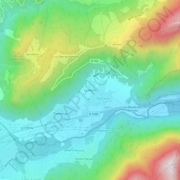
Name: Le Villard topographic map, elevation, terrain.
Average elevation: 754 m
Minimum elevation: 435 m
Maximum elevation: 1,486 m
Other topographic maps
Click on a map to view its topography, its elevation and its terrain.
Cons-Sainte-Colombe
France > Auvergne-Rhône-Alpes > Haute-Savoie > Val de Chaise
Average elevation: 782 m
Marlens
France > Auvergne-Rhône-Alpes > Haute-Savoie > Val de Chaise
La situation de Marlens se trouve dans un climat continental montagnard caractérisé par une humidité marquée. Les données utilisées par Météo-France pour caractériser le climat local reprennent celles de la station météorologique de référence, située à Chambéry (située à environ 35 km au…
Average elevation: 842 m