Geolocate

Lamongan topographic map

Click on the map to display elevation.

About this map

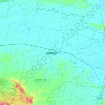
Name: Lamongan topographic map, elevation, terrain.

Location: Lamongan, East Java, Java, 62211, Indonesia (-7.28044 112.25559 -6.96044 112.57559)

Average elevation: 16 m

Minimum elevation: -1 m

Maximum elevation: 179 m

Other topographic maps

Click on a map to view its topography, its elevation and its terrain.

Wonorejo

Indonesia > East Java > Lamongan > Sambeng

Average elevation: 81 m

Bluluk

Indonesia > East Java > Lamongan

Average elevation: 73 m

Ngimbang

Indonesia > East Java > Lamongan

Average elevation: 89 m

Pataan

Indonesia > East Java > Lamongan > Sambeng

Average elevation: 102 m

Pamotan

Indonesia > East Java > Lamongan > Sambeng

Average elevation: 78 m

Garung

Indonesia > East Java > Lamongan > Sambeng

Average elevation: 76 m

Selorejo

Indonesia > East Java > Lamongan > Sambeng

Average elevation: 55 m

Sambeng

Indonesia > East Java > Lamongan

Average elevation: 79 m

Sukorame

Indonesia > East Java > Lamongan

Average elevation: 101 m

Jejel

Indonesia > East Java > Lamongan > Ngimbang

Average elevation: 80 m

Gear up for your next adventure:

🧥Thermal Fleece Jacket - Versatile insulation for changing mountain temperatures
🔦LED Flashlight - Powerful and long-lasting flashlight for camping and emergencies
🛁Quick-Dry Microfiber Towel - Space-saving towel that dries rapidly on the move
👟Leg Gaiters - Keep debris, mud, and snow out of your boots
Camping Tent - Weather-resistant tents suitable for 2 to 6 people

As an Amazon Associate, this site earns from qualifying purchases at no extra cost to you.