
Make a donation
Gear up for your next adventure:
As an Amazon Associate, this site earns from qualifying purchases at no extra cost to you.
Huninquiri topographic map
Click on the map to display elevation.
Make a donation
Gear up for your next adventure:
As an Amazon Associate, this site earns from qualifying purchases at no extra cost to you.
About this map
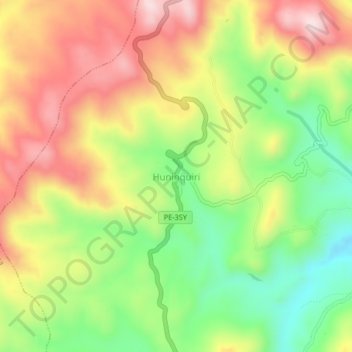
Name: Huninquiri topographic map, elevation, terrain.
Location: Huninquiri, Chamaca, Chumbivilcas, Cusco, Perú (-14.30903 -71.96810 -14.26903 -71.92810)
Average elevation: 3,979 m
Minimum elevation: 3,793 m
Maximum elevation: 4,174 m
Make a donation
Gear up for your next adventure:
As an Amazon Associate, this site earns from qualifying purchases at no extra cost to you.
Other topographic maps
Click on a map to view its topography, its elevation and its terrain.
Ingata
Ingata es un centro poblado ubicado en el distrito de Chamaca, en la provincia de Chumbivilcas, departamento de Cusco, en Perú. Se encuentra a una altitud de 3960 metros sobre el nivel del mar. Se sitúa a 20 kilómetros de la sede del distrito, Chamaca, y a una distancia de más de 50 kilómetros de la…
Average elevation: 3,909 m