Geolocate

Maligaya topographic map

Click on the map to display elevation.

About this map

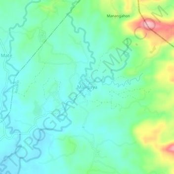
Name: Maligaya topographic map, elevation, terrain.

Location: Maligaya, Rosario, Agusan del Sur, Caraga, Philippines (8.40537 126.01297 8.44537 126.05297)

Average elevation: 78 m

Minimum elevation: 36 m

Maximum elevation: 200 m

Other topographic maps

Click on a map to view its topography, its elevation and its terrain.

Solibao River

Philippines > Agusan del Sur > Rosario

Average elevation: 24 m

Gear up for your next adventure:

🧥Softshell Jacket - Windproof and breathable jacket for hiking
🧊Insulated Water Bottle - Keeps drinks cold in summer and prevents freezing in winter
Camping Groundsheet - Protect your tent from moisture and dirt
🧳Compression Sacks - Maximize space in your backpack by shrinking gear
🛁Quick-Dry Microfiber Towel - Space-saving towel that dries rapidly on the move

As an Amazon Associate, this site earns from qualifying purchases at no extra cost to you.