Geolocate

Talara topographic map

Interactive map

Click on the map to display elevation.

About this map

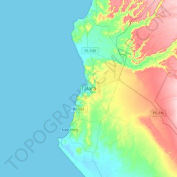
Name: Talara topographic map, elevation, terrain.

Location: Talara, Pariñas, Talara, Piura, Peru (-4.73969 -81.43183 -4.41969 -81.11183)

Average elevation: 45 m

Minimum elevation: -5 m

Maximum elevation: 191 m

Other topographic maps

Click on a map to view its topography, its elevation and its terrain.

La Arena

Peru > Piura

La Arena, Piura, Peru

Average elevation: 26 m

Catacaos

Peru > Piura

Catacaos, Piura, 20006, Peru

Average elevation: 68 m

BA

Peru > Piura > Castilla

BA, Urbanización Miraflores Country Club, Castilla, Piura, 20002, Peru

Average elevation: 34 m

Belizario

Peru > Piura > Sechura > Belizario

Belizario, Sechura, Piura, Peru

Average elevation: 20 m