
Make a donation
Gear up for your next adventure:
As an Amazon Associate, this site earns from qualifying purchases at no extra cost to you.
Am Staden topographic map
Click on the map to display elevation.
Make a donation
Gear up for your next adventure:
As an Amazon Associate, this site earns from qualifying purchases at no extra cost to you.
About this map
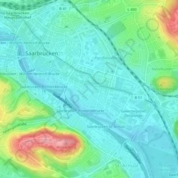
Name: Am Staden topographic map, elevation, terrain.
Average elevation: 215 m
Minimum elevation: 185 m
Maximum elevation: 305 m
Make a donation
Gear up for your next adventure:
As an Amazon Associate, this site earns from qualifying purchases at no extra cost to you.
Other topographic maps
Click on a map to view its topography, its elevation and its terrain.
Staffelberg
Deutschland > Saarland > Regionalverband Saarbrücken > Saarbrücken
Average elevation: 331 m
Großer Homburg
Deutschland > Saarland > Regionalverband Saarbrücken > Saarbrücken
Average elevation: 259 m
Neu-Aschbach
Deutschland > Saarland > Regionalverband Saarbrücken > Saarbrücken
Average elevation: 233 m
Make a donation
Gear up for your next adventure:
As an Amazon Associate, this site earns from qualifying purchases at no extra cost to you.
Pfaffenkopf
Deutschland > Saarland > Regionalverband Saarbrücken > Saarbrücken
Average elevation: 294 m