Geolocate

Emgwen topographic map

Interactive map

Click on the map to display elevation.

About this map

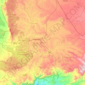
Name: Emgwen topographic map, elevation, terrain.

Location: Emgwen, Nandi County, Rift Valley, Kenya (0.07790 34.90571 0.29466 35.29650)

Average elevation: 1,946 m

Minimum elevation: 1,299 m

Maximum elevation: 2,515 m

Other topographic maps

Click on a map to view its topography, its elevation and its terrain.

Chesumei

Kenya > Nandi County

Chesumei, Nandi County, Rift Valley, 30306, Kenya

Average elevation: 1,966 m

Mosop

Kenya > Nandi County

Mosop, Nandi County, Rift Valley, Kenya

Average elevation: 1,936 m

Aldai

Kenya > Nandi County

Aldai, Nandi County, Rift Valley, Kenya

Average elevation: 1,608 m

Tinderet

Kenya > Nandi County

Tinderet, Nandi County, Rift Valley, Kenya

Average elevation: 1,883 m

Nandi Hills

Kenya > Nandi County

Nandi Hills, Nandi County, Rift Valley, Kenya

Average elevation: 1,983 m