
Make a donation
Gear up for your next adventure:
As an Amazon Associate, this site earns from qualifying purchases at no extra cost to you.
Orrstown topographic map
Click on the map to display elevation.
Make a donation
Gear up for your next adventure:
As an Amazon Associate, this site earns from qualifying purchases at no extra cost to you.
About this map
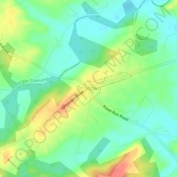
Name: Orrstown topographic map, elevation, terrain.
Location: Orrstown, Franklin County, Pennsylvania, United States (40.05598 -77.61277 40.06113 -77.60141)
Average elevation: 193 m
Minimum elevation: 172 m
Maximum elevation: 228 m
Make a donation
Gear up for your next adventure:
As an Amazon Associate, this site earns from qualifying purchases at no extra cost to you.
Other topographic maps
Click on a map to view its topography, its elevation and its terrain.
Zullinger
United States > Pennsylvania > Franklin County > Washington Township
Average elevation: 216 m
Williamson
United States > Pennsylvania > Franklin County > St. Thomas Township
Average elevation: 166 m
Make a donation
Gear up for your next adventure:
As an Amazon Associate, this site earns from qualifying purchases at no extra cost to you.
Welsh Run
United States > Pennsylvania > Franklin County > Montgomery Township
Average elevation: 161 m
Make a donation
Gear up for your next adventure:
As an Amazon Associate, this site earns from qualifying purchases at no extra cost to you.
Upper Strasburg
United States > Pennsylvania > Franklin County > Letterkenny Township
Average elevation: 263 m
Tomstown
United States > Pennsylvania > Franklin County > Quincy Township > Quincy
Average elevation: 264 m
Stoufferstown
United States > Pennsylvania > Franklin County > Guilford Township
Average elevation: 208 m
Make a donation
Gear up for your next adventure:
As an Amazon Associate, this site earns from qualifying purchases at no extra cost to you.
South Mountain
United States > Pennsylvania > Franklin County > Quincy Township
Average elevation: 499 m
Shimpstown
United States > Pennsylvania > Franklin County > Montgomery Township
Average elevation: 174 m
Make a donation
Gear up for your next adventure:
As an Amazon Associate, this site earns from qualifying purchases at no extra cost to you.
Richmond Furnace
United States > Pennsylvania > Franklin County > Metal Township
Average elevation: 340 m
Pleasant Hall
United States > Pennsylvania > Franklin County > Letterkenny Township
Average elevation: 208 m
Make a donation
Gear up for your next adventure:
As an Amazon Associate, this site earns from qualifying purchases at no extra cost to you.
New Franklin
United States > Pennsylvania > Franklin County > Guilford Township
Average elevation: 231 m
Monterey
United States > Pennsylvania > Franklin County > Washington Township
Average elevation: 403 m
Make a donation
Gear up for your next adventure:
As an Amazon Associate, this site earns from qualifying purchases at no extra cost to you.
Mason and Dixon
United States > Pennsylvania > Franklin County > Antrim Township
Average elevation: 178 m
Mainsville
United States > Pennsylvania > Franklin County > Southampton Township
Average elevation: 245 m
Make a donation
Gear up for your next adventure:
As an Amazon Associate, this site earns from qualifying purchases at no extra cost to you.
Kasiesville
United States > Pennsylvania > Franklin County > Montgomery Township
Average elevation: 209 m
Make a donation
Gear up for your next adventure:
As an Amazon Associate, this site earns from qualifying purchases at no extra cost to you.
Make a donation
Gear up for your next adventure:
As an Amazon Associate, this site earns from qualifying purchases at no extra cost to you.
Make a donation
Gear up for your next adventure:
As an Amazon Associate, this site earns from qualifying purchases at no extra cost to you.
Claylick
United States > Pennsylvania > Franklin County > Montgomery Township
Average elevation: 180 m
Cheesetown
United States > Pennsylvania > Franklin County > Hamilton Township
Average elevation: 204 m
Make a donation
Gear up for your next adventure:
As an Amazon Associate, this site earns from qualifying purchases at no extra cost to you.
Blue Ridge Summit
United States > Pennsylvania > Franklin County > Washington Township
Average elevation: 400 m
Make a donation
Gear up for your next adventure:
As an Amazon Associate, this site earns from qualifying purchases at no extra cost to you.
Saint Thomas
United States > Pennsylvania > Franklin County > St. Thomas Township
Average elevation: 193 m
Cowans Gap
United States > Pennsylvania > Franklin County > Metal Township > Cowans Village
Average elevation: 402 m
Make a donation
Gear up for your next adventure:
As an Amazon Associate, this site earns from qualifying purchases at no extra cost to you.
Caledonia State Park
United States > Pennsylvania > Franklin County > Greene Township > Caledonia Park
Average elevation: 367 m