
Thank you for supporting this site ❤️
Make a donation
Make a donation
Gear up for your next adventure:
As an Amazon Associate, this site earns from qualifying purchases at no extra cost to you.
Muthill topographic map
Click on the map to display elevation.
Thank you for supporting this site ❤️
Make a donation
Make a donation
Gear up for your next adventure:
As an Amazon Associate, this site earns from qualifying purchases at no extra cost to you.
About this map
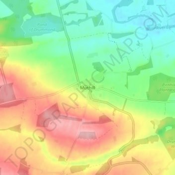
Name: Muthill topographic map, elevation, terrain.
Location: Muthill, Perth and Kinross, Scotland, PH5 2AW, United Kingdom (56.31176 -3.85346 56.35176 -3.81346)
Average elevation: 85 m
Minimum elevation: 25 m
Maximum elevation: 162 m
Thank you for supporting this site ❤️
Make a donation
Make a donation
Gear up for your next adventure:
As an Amazon Associate, this site earns from qualifying purchases at no extra cost to you.