Geolocate

Spencer topographic map

Click on the map to display elevation.

About this map

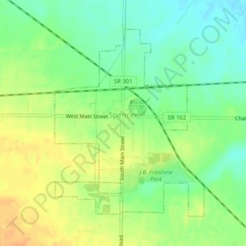
Name: Spencer topographic map, elevation, terrain.

Location: Spencer, Medina County, Ohio, United States (41.08914 -82.13321 41.10970 -82.11141)

Average elevation: 278 m

Minimum elevation: 262 m

Maximum elevation: 295 m

Other topographic maps

Click on a map to view its topography, its elevation and its terrain.

Homerville

United States > Ohio > Medina County

Average elevation: 330 m

Valley City Station

United States > Ohio > Medina County

Average elevation: 273 m

Reeds Hill

United States > Ohio > Medina County

Average elevation: 330 m

Chippewa Lake Park

United States > Ohio > Medina County > Medina

Average elevation: 321 m

Wordens Ledges

United States > Ohio > Medina County

Average elevation: 330 m

River Corners

United States > Ohio > Medina County

Average elevation: 268 m

South Pond

United States > Ohio > Medina County

Average elevation: 341 m

Gear up for your next adventure:

🧥Waterproof Jacket - Lightweight rain jackets for hiking and outdoor activities
🔭Compact Monocular - One-handed bird watching and trail spotting
🥾Waterproof Hiking Boots - Boots keeping your feet dry in wet conditions
🦟Insect Repellent - Keep mosquitoes and black flies away in wooded areas
💧Reusable Water Bottle - Durable water bottles for hydration on trails

As an Amazon Associate, this site earns from qualifying purchases at no extra cost to you.