Geolocate

Cibingbin topographic map

Click on the map to display elevation.

About this map

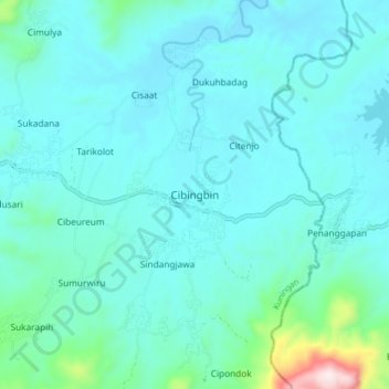
Name: Cibingbin topographic map, elevation, terrain.

Location: Cibingbin, Kuningan, West Java, Java, Indonesia (-7.09477 108.71853 -7.01477 108.79853)

Average elevation: 123 m

Minimum elevation: 36 m

Maximum elevation: 728 m

Other topographic maps

Click on a map to view its topography, its elevation and its terrain.

Gear up for your next adventure:

🛏️Camping Sleeping Mat - Comfortable mats for sleeping outdoors
🥾Trekking Boots - Durable boots for long-distance trekking
🧦Hiking Socks - Moisture-wicking and comfortable socks for long hikes
🥾Trail Running Shoes - Lightweight and durable shoes for trail running
🥾Hiking Leggings - Comfortable leggings for outdoor activities

As an Amazon Associate, this site earns from qualifying purchases at no extra cost to you.