Geolocate

Mojorejo topographic map

Click on the map to display elevation.

About this map

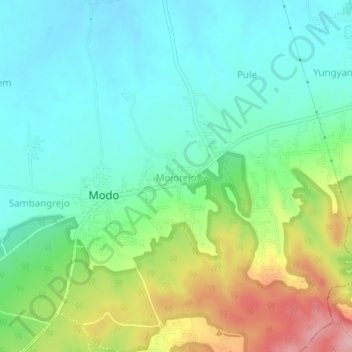
Name: Mojorejo topographic map, elevation, terrain.

Location: Mojorejo, Lamongan, East Java, Java, Indonesia (-7.25770 112.13652 -7.21770 112.17652)

Average elevation: 79 m

Minimum elevation: 30 m

Maximum elevation: 191 m

Other topographic maps

Click on a map to view its topography, its elevation and its terrain.

Wonorejo

Indonesia > East Java > Lamongan > Sambeng

Average elevation: 81 m

Bluluk

Indonesia > East Java > Lamongan

Average elevation: 73 m

Ngimbang

Indonesia > East Java > Lamongan

Average elevation: 89 m

Pataan

Indonesia > East Java > Lamongan > Sambeng

Average elevation: 102 m

Pamotan

Indonesia > East Java > Lamongan > Sambeng

Average elevation: 78 m

Garung

Indonesia > East Java > Lamongan > Sambeng

Average elevation: 76 m

Selorejo

Indonesia > East Java > Lamongan > Sambeng

Average elevation: 55 m

Sambeng

Indonesia > East Java > Lamongan

Average elevation: 79 m

Sukorame

Indonesia > East Java > Lamongan

Average elevation: 101 m

Jejel

Indonesia > East Java > Lamongan > Ngimbang

Average elevation: 80 m

Gear up for your next adventure:

🚲Bike Repair Kit - Essential tools for on-trail mechanical issues
Backpacking Tent - Lightweight tent for long-distance hiking trips
🦟Insect Repellent - Keep mosquitoes and black flies away in wooded areas
🎒Fully Waterproof Backpack - Total protection for photography gear and electronics
Lightweight Backpacking Tent - Compact tent for efficient hiking trips

As an Amazon Associate, this site earns from qualifying purchases at no extra cost to you.