Geolocate

Eastern Desert topographic map

Click on the map to display elevation.

About this map

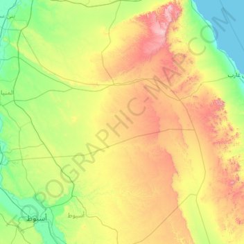
Name: Eastern Desert topographic map, elevation, terrain.

Location: Eastern Desert, Al Minya, Egypt (26.96350 30.98187 28.96350 32.98187)

Average elevation: 403 m

Minimum elevation: 0 m

Maximum elevation: 1,684 m

Other topographic maps

Click on a map to view its topography, its elevation and its terrain.

New Al Minya

Egypt > Al Minya

Average elevation: 111 m

Al Fekreya City

Egypt > Al Minya

Average elevation: 42 m

New Al Minya

Egypt > Al Minya

Average elevation: 111 m

Smalout City

Egypt > Al Minya

Average elevation: 38 m

Sayed Galal

Egypt > Al Minya > Sayed Galal

Average elevation: 41 m

Gear up for your next adventure:

🔭Compact Monocular - One-handed bird watching and trail spotting
🥾Trail Hiking Shoes - Durable shoes designed for rugged trails
🔋Solar Power Bank - Keep your GPS and devices charged during long outdoor trips
❄️Traction Ice Cleats - Slip-on spikes for icy trails and winter hiking
🧥Thermal Layer - Insulating layer for cold outdoor conditions

As an Amazon Associate, this site earns from qualifying purchases at no extra cost to you.