
Nottely Lake topographic map
Click on the map to display elevation.
About this map
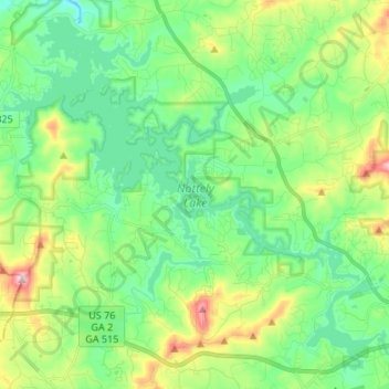
Name: Nottely Lake topographic map, elevation, terrain.
Location: Nottely Lake, Union County, Georgia, 30512, United States (34.86001 -84.11573 34.96157 -83.98116)
Average elevation: 587 m
Minimum elevation: 490 m
Maximum elevation: 824 m
Other topographic maps
Click on a map to view its topography, its elevation and its terrain.
Blood Mountain
United States > Georgia > Union County
Blood Mountain is the highest peak on the Georgia section of the Appalachian Trail and the sixth-tallest mountain in Georgia, with an elevation of 4,458 feet (1,359 m). It is located on the border of Lumpkin County with Union County and is within the boundaries of the Chattahoochee National Forest and the…
Average elevation: 1,048 m