Geolocate

Frankenau topographic map

Click on the map to display elevation.

About this map
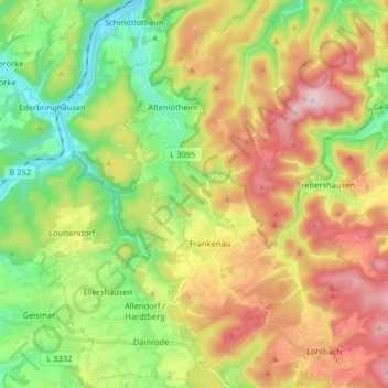
Name: Frankenau topographic map, elevation, terrain.

Location: Frankenau, Landkreis Waldeck-Frankenberg, Hessen, 35110, Duitsland (51.05595 8.83606 51.15735 8.99414)

Average elevation: 410 m

Minimum elevation: 248 m

Maximum elevation: 625 m

Other topographic maps

Click on a map to view its topography, its elevation and its terrain.

Gear up for your next adventure:

🔦LED Flashlight - Powerful and long-lasting flashlight for camping and emergencies
🌬️Windproof Camp Stove - Efficient cooking even on exposed mountain peaks
🧢Sun Protection Cap - Breathable cap to protect from sun exposure
🎒Backpack Rain Cover - External shield to keep your entire pack dry
💧Hydration Bladder - Hands-free hydration solution for long treks

As an Amazon Associate, this site earns from qualifying purchases at no extra cost to you.