
Make a donation
Gear up for your next adventure:
As an Amazon Associate, this site earns from qualifying purchases at no extra cost to you.
Bous topographic map
Click on the map to display elevation.
Make a donation
Gear up for your next adventure:
As an Amazon Associate, this site earns from qualifying purchases at no extra cost to you.
Bous
Das Thalia wurde 1957 eröffnet und seither jedoch mehrfach modernisiert, ohne seinen Wirtschaftswundercharme einzubüßen. Technisch befindet es sich auf der Höhe der Zeit. Das Kino hat 141 Plätze und bietet Service am Platz.
Make a donation
Gear up for your next adventure:
As an Amazon Associate, this site earns from qualifying purchases at no extra cost to you.
About this map
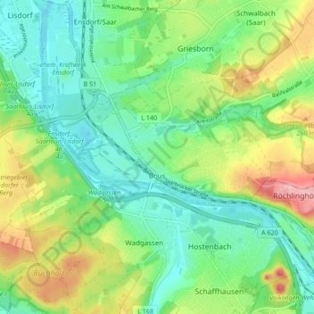
Name: Bous topographic map, elevation, terrain.
Location: Bous, Landkreis Saarlouis, Saarland, 66359, Deutschland (49.26981 6.77470 49.28703 6.85852)
Average elevation: 217 m
Minimum elevation: 173 m
Maximum elevation: 303 m
Make a donation
Gear up for your next adventure:
As an Amazon Associate, this site earns from qualifying purchases at no extra cost to you.