Geolocate

To topographic map

Click on the map to display elevation.

About this map

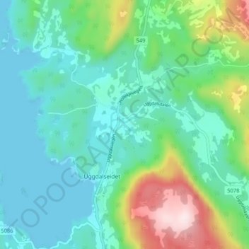
Name: To topographic map, elevation, terrain.

Location: To, Uggdalseidet, Tysnes, Vestland, 5685, Norway (59.98572 5.48160 60.02572 5.52160)

Average elevation: 108 m

Minimum elevation: -9 m

Maximum elevation: 452 m

Gear up for your next adventure:

🥾Hiking Boots - Sturdy boots providing ankle support and traction on rugged trails
🧭GPS Outdoor Watch - Smart watch for navigation and fitness tracking in nature
📷Outdoor Action Camera - Capture high-elevation views and rugged adventures
🥾Lightweight Hiking Boots - Boots for comfort and mobility on long hikes
Camping Groundsheet - Protect your tent from moisture and dirt

As an Amazon Associate, this site earns from qualifying purchases at no extra cost to you.