
Thank you for supporting this site ❤️
Make a donation
Make a donation
Gear up for your next adventure:
As an Amazon Associate, this site earns from qualifying purchases at no extra cost to you.
Immoula topographic map
Click on the map to display elevation.
Thank you for supporting this site ❤️
Make a donation
Make a donation
Gear up for your next adventure:
As an Amazon Associate, this site earns from qualifying purchases at no extra cost to you.
About this map
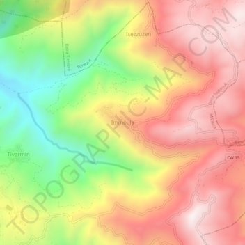
Name: Immoula topographic map, elevation, terrain.
Location: Immoula, M'Cisna, Daïra Seddouk, Béjaïa, 06038, Algérie (36.55430 4.72265 36.59430 4.76265)
Average elevation: 754 m
Minimum elevation: 270 m
Maximum elevation: 1,138 m
Thank you for supporting this site ❤️
Make a donation
Make a donation
Gear up for your next adventure:
As an Amazon Associate, this site earns from qualifying purchases at no extra cost to you.