Geolocate

Balongsari topographic map

Click on the map to display elevation.

About this map

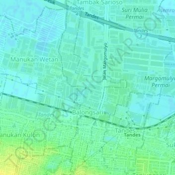
Name: Balongsari topographic map, elevation, terrain.

Location: Balongsari, Tandes, Surabaya, East Java, Java, Indonesia (-7.26714 112.67387 -7.23618 112.68606)

Average elevation: 6 m

Minimum elevation: 0 m

Maximum elevation: 19 m

Other topographic maps

Click on a map to view its topography, its elevation and its terrain.

Asemrowo

Indonesia > East Java > Surabaya

Average elevation: 4 m

Taman Prestasi

Indonesia > East Java > Surabaya > Ketabang

Average elevation: 6 m

Dukuh Pakis

Indonesia > East Java > Surabaya

Average elevation: 9 m

Dukuh Pakis

Indonesia > East Java > Surabaya

Average elevation: 15 m

Gear up for your next adventure:

🥾Waterproof Hiking Boots - Boots keeping your feet dry in wet conditions
🥾All-Terrain Hiking Boots - Versatile boots for varied hiking conditions
🧢Hiking Hat - Sun-protective and breathable hats for long treks
🕯️Camping Lantern - Illuminates your entire campsite with high-efficiency LEDs
Camping Essentials - All-in-one gear for a comfortable camping trip

As an Amazon Associate, this site earns from qualifying purchases at no extra cost to you.