Geolocate

Bergland topographic map

Click on the map to display elevation.

About this map

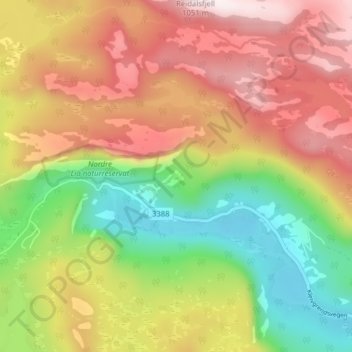
Name: Bergland topographic map, elevation, terrain.

Location: Bergland, Fyresdal, Telemark, Norway (59.22845 7.88681 59.26845 7.92681)

Average elevation: 713 m

Minimum elevation: 409 m

Maximum elevation: 1,025 m

Other topographic maps

Click on a map to view its topography, its elevation and its terrain.

Seljord

Norway > Telemark

Average elevation: 720 m

Drangedal

Norway > Telemark

Average elevation: 320 m

Nissedal

Norway > Telemark

Average elevation: 500 m

Kragerø

Norway > Telemark

Average elevation: 47 m

Notodden

Norway > Telemark

Notodden has a humid continental climate (Dfb), with cold winters and mild summers. Situated inland at low altitude in the Telemark region, it is one of the warmer towns in Norway during summer. The weather station at Notodden Airport has been recording since March 1970 (temperature and wind speed).…

Average elevation: 553 m

Sandane

Norway > Telemark

Average elevation: 625 m

Bordalsvatn

Norway > Telemark

Average elevation: 1,017 m

Vinje

Norway > Telemark

Average elevation: 1,106 m

Porsgrunn

Norway > Telemark

Average elevation: 87 m

Seljord

Norway > Telemark

Average elevation: 720 m

Hjartdal

Norway > Telemark

Average elevation: 796 m

Store Såstein

Norway > Telemark

Average elevation: 3 m

Skien

Norway > Telemark

Average elevation: 239 m

Tokke

Norway > Telemark

Average elevation: 814 m

Vinje

Norway > Telemark

Average elevation: 1,106 m

Gear up for your next adventure:

🧥Waterproof Jacket - Lightweight rain jackets for hiking and outdoor activities
🔦LED Headtorch - Bright and durable light for night activities
🧼Travel Hand Sanitizer - Keep hands clean when water is scarce
🔦LED Headlamp - Hands-free lighting for early morning starts or late finishes
💧Reusable Water Bottle - Durable water bottles for hydration on trails

As an Amazon Associate, this site earns from qualifying purchases at no extra cost to you.