Geolocate

Tai Po topographic map

Click on the map to display elevation.

About this map

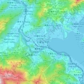
Name: Tai Po topographic map, elevation, terrain.

Location: Tai Po, Tai Po District, New Territories, Hong Kong, China (22.40940 114.13113 22.48940 114.21113)

Average elevation: 155 m

Minimum elevation: -3 m

Maximum elevation: 836 m

Other topographic maps

Click on a map to view its topography, its elevation and its terrain.

Grass Island

China > Hong Kong > Tai Po District > Sheung Wai

Average elevation: 7 m

Ping Chau

China > Hong Kong > Tai Po District > Sha Tau > Tsoi Uk

Average elevation: 1 m

Flat Island

China > Hong Kong > Tai Po District

Average elevation: 17 m

Ping Chau

China > Hong Kong > Tai Po District > Sha Tau > Tsoi Uk

Average elevation: 1 m

Gear up for your next adventure:

🔋Lithium AA Batteries - Long-lasting power that performs in extreme cold
👖Convertible Hiking Pants - Zip-off legs to adapt to changing weather conditions
🥾Hiking Boots - Sturdy boots providing ankle support and traction on rugged trails
🥾Waterproof Trail Shoes - Shoes designed to handle wet terrain
🥾Trail Running Shoes - Lightweight and durable shoes for trail running

As an Amazon Associate, this site earns from qualifying purchases at no extra cost to you.