
Make a donation
Gear up for your next adventure:
As an Amazon Associate, this site earns from qualifying purchases at no extra cost to you.
Black Hill topographic map
Click on the map to display elevation.
Make a donation
Gear up for your next adventure:
As an Amazon Associate, this site earns from qualifying purchases at no extra cost to you.
About this map
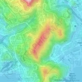
Name: Black Hill topographic map, elevation, terrain.
Average elevation: 93 m
Minimum elevation: -1 m
Maximum elevation: 314 m
Make a donation
Gear up for your next adventure:
As an Amazon Associate, this site earns from qualifying purchases at no extra cost to you.
Other topographic maps
Click on a map to view its topography, its elevation and its terrain.
Basalt Island
China > Hong Kong > Sai Kung District
Basalt Island is located south of Town Island and Wang Chau, east of Bluff Island and north of the Ninepin Group. Its highest elevation is 174 m. Notably, despite its name is “Basalt Island”, the rocks that forms the island are indeed rhyolitic tuff.
Average elevation: 6 m
Make a donation
Gear up for your next adventure:
As an Amazon Associate, this site earns from qualifying purchases at no extra cost to you.
Kiu Tsui Country Park
China > Hong Kong > Sai Kung District > Sai Kung > Kiu Tsui
Average elevation: 4 m
Make a donation
Gear up for your next adventure:
As an Amazon Associate, this site earns from qualifying purchases at no extra cost to you.