Geolocate

Triple Divide Peak topographic map

Click on the map to display elevation.

About this map

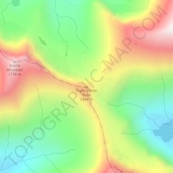
Name: Triple Divide Peak topographic map, elevation, terrain.

Location: Triple Divide Peak, Glacier County, Montana, United States (48.57298 -113.51682 48.57308 -113.51672)

Average elevation: 2,136 m

Minimum elevation: 1,690 m

Maximum elevation: 2,722 m

Other topographic maps

Click on a map to view its topography, its elevation and its terrain.

Hidden Lake

United States > Montana > Glacier County

Average elevation: 1,416 m

Gem Glacier

United States > Montana > Glacier County

Average elevation: 2,150 m

Logan Glacier

United States > Montana > Glacier County

Average elevation: 2,232 m

Grinnell Glacier

United States > Montana > Glacier County

Average elevation: 2,133 m

Blackfoot Glacier

United States > Montana > Glacier County

Average elevation: 2,316 m

Jackson Glacier

United States > Montana > Glacier County

Average elevation: 2,268 m

Iceberg Lake

United States > Montana > Glacier County

Average elevation: 2,163 m

Hope Lake

United States > Montana > Glacier County

Average elevation: 1,179 m

Lake Josephine

United States > Montana > Glacier County

Average elevation: 1,716 m

Browning

United States > Montana > Glacier County

Average elevation: 1,338 m

Logan Glacier

United States > Montana > Glacier County

Average elevation: 2,232 m

Pray Lake

United States > Montana > Glacier County

Average elevation: 1,717 m

Gear up for your next adventure:

🩹Compact First Aid Kit - Pre-packed essentials for common trail injuries
🥫Freeze-Dried Meals - Lightweight, high-calorie nutrition for multi-day treks
Camping Coffee Maker - Brew fresh coffee anywhere on the topographic map
🧦Hiking Liner Socks - Thin base layer to prevent friction and blisters
🧰Survival Kit - Essential gear for emergencies in the wilderness

As an Amazon Associate, this site earns from qualifying purchases at no extra cost to you.