Geolocate

Patkot topographic map

Click on the map to display elevation.

About this map

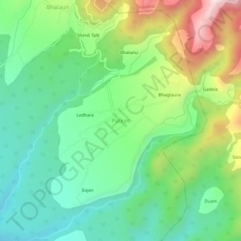
Name: Patkot topographic map, elevation, terrain.

Location: Patkot, Ramnagar, Nainital, India (29.42803 79.24043 29.46803 79.28043)

Average elevation: 796 m

Minimum elevation: 577 m

Maximum elevation: 1,231 m

Gear up for your next adventure:

🥾Lightweight Hiking Shoes - Comfortable shoes for day hikes
💡LED Camping Lantern - Illuminate your campsite with long-lasting lanterns
💡Portable Camping Lamp - Rechargeable lamp for campsite lighting
🥾Durable Hiking Shoes - Long-lasting shoes for frequent hiking
🛶Canoe Life Vest - Safety vest for water sports

As an Amazon Associate, this site earns from qualifying purchases at no extra cost to you.