Geolocate

Oro topographic map

Click on the map to display elevation.

About this map

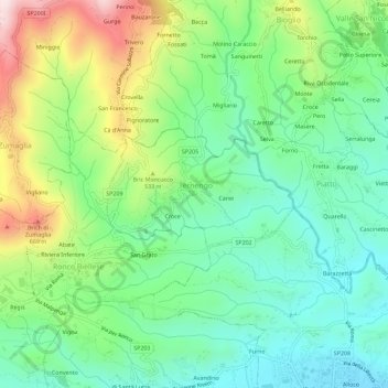
Name: Oro topographic map, elevation, terrain.

Location: Oro, Ternengo, Biella, Piemont, 13844, Italy (45.56878 8.09584 45.60878 8.13584)

Average elevation: 432 m

Minimum elevation: 275 m

Maximum elevation: 753 m

Gear up for your next adventure:

🥾Trekking Poles - Adjustable trekking poles to reduce knee stress and improve stability
🛌Insulated Sleeping Pad - Critical thermal barrier between you and the cold ground
🥾Waterproof Hiking Boots - Boots keeping your feet dry in wet conditions
🧥Waterproof Pants - Keep dry during rainy hiking conditions
Tent Footprint - Protect tent floor and increase durability

As an Amazon Associate, this site earns from qualifying purchases at no extra cost to you.