Geolocate

Taboche topographic map

Click on the map to display elevation.

About this map

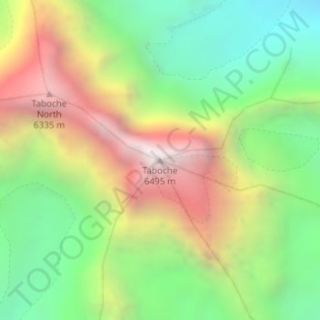
Name: Taboche topographic map, elevation, terrain.

Location: Taboche, Khumbupasanglahmu, Solukhumbu, Koshi Province, Nepal (27.89726 86.77932 27.89736 86.77942)

Average elevation: 5,416 m

Minimum elevation: 4,633 m

Maximum elevation: 6,482 m

Other topographic maps

Click on a map to view its topography, its elevation and its terrain.

Likhupike

Nepal > Koshi Province > Solukhumbu

Average elevation: 2,755 m

Sotang

Nepal > Koshi Province > Solukhumbu

Average elevation: 2,173 m

West Ridge

Nepal > Koshi Province > Solukhumbu

Average elevation: 7,035 m

Khumbupasanglahmu-05

Nepal > Koshi Province > Solukhumbu

Average elevation: 5,232 m

Gear up for your next adventure:

🪜Heavy Duty Carabiners - Multi-use clips for securing gear to your backpack
🥾Trail Running Shoes - Lightweight and durable shoes for trail running
🔦LED Headtorch - Bright and durable light for night activities
🛌Down Sleeping Bag - Superior warmth-to-weight ratio for cold nights
🛌Insulated Sleeping Pad - Critical thermal barrier between you and the cold ground

As an Amazon Associate, this site earns from qualifying purchases at no extra cost to you.