
Lander County topographic map
Interactive map
Click on the map to display elevation.
About this map
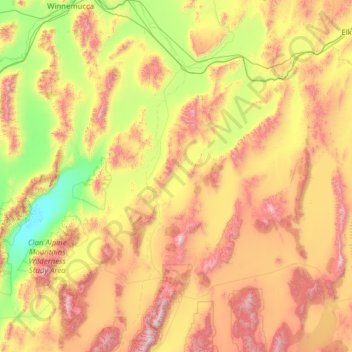
Name: Lander County topographic map, elevation, terrain.
Location: Lander County, Nevada, Estados Unidos de América (39.09334 -117.80528 41.00114 -116.58745)
Average elevation: 1,768 m
Minimum elevation: 1,030 m
Maximum elevation: 3,354 m
Other topographic maps
Click on a map to view its topography, its elevation and its terrain.
Kingston
Estados Unidos de América > Nevada > Kingston
Kingston, Lander County, Nevada, 89310, Estados Unidos de América
Average elevation: 1,871 m
North Las Vegas
Estados Unidos de América > Nevada > North Las Vegas
North Las Vegas, Clark County, Nevada, Estados Unidos de América
Average elevation: 682 m