Geolocate

Trnava topographic map

Click on the map to display elevation.

Trnava

Trnava lies at an altitude of 146 metres (479 ft) above sea level and covers an area of 71.535 square kilometres (27.6 sq mi). It is located in the Danubian Lowland on the Trnávka river, around 45 kilometres (28 mi) north-east of Bratislava, 50 kilometres (31 mi) west of Nitra and around 70 kilometres (43 mi) from the Czech border. The closest mountain ranges are the Little Carpathians to the west and the Považský Inovec to the north-east of the city.

Wikipedia (CC-BY-SA 3.0)

About this map

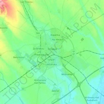
Name: Trnava topographic map, elevation, terrain.

Location: Trnava, District of Trnava, Region of Trnava, Western Slovakia, Slovakia (48.31860 17.48744 48.42784 17.65951)

Average elevation: 154 m

Minimum elevation: 129 m

Maximum elevation: 228 m

Gear up for your next adventure:

🧦Merino Wool Socks - Moisture-wicking comfort for long-distance hiking
💧Collapsible Water Bottle - Space-saving water bottle for outdoor activities
🔦UV Flashlight - Detect minerals or specific insects in the dark
🔦LED Flashlight - Powerful and long-lasting flashlight for camping and emergencies
Lightweight Camping Tent - Portable shelter optimized for Canadian backcountry camping

As an Amazon Associate, this site earns from qualifying purchases at no extra cost to you.