
Izvoarele topographic map
Interactive map
Click on the map to display elevation.
About this map
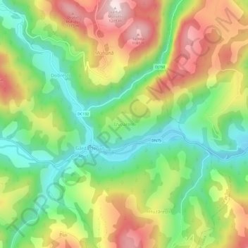
Name: Izvoarele topographic map, elevation, terrain.
Location: Izvoarele, Gârda de Sus, Alba, 517321, Roumanie (46.43927 22.81650 46.47927 22.85650)
Average elevation: 921 m
Minimum elevation: 707 m
Maximum elevation: 1,203 m
Other topographic maps
Click on a map to view its topography, its elevation and its terrain.
Cornu
Roumanie > Alba > Bucerdea Grânoasă
Cornu, Bucerdea Grânoasă, Alba, 517262, Roumanie
Average elevation: 348 m