Geolocate

Mekarwangi topographic map

Click on the map to display elevation.

About this map

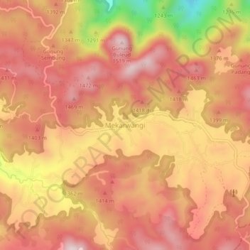
Name: Mekarwangi topographic map, elevation, terrain.

Location: Mekarwangi, West Bandung, West Java, Java, Indonesia (-7.08325 107.37771 -7.04325 107.41771)

Average elevation: 1,331 m

Minimum elevation: 992 m

Maximum elevation: 1,495 m

Other topographic maps

Click on a map to view its topography, its elevation and its terrain.

Bosscha Observatory

Indonesia > West Java > West Bandung > Lembang

Average elevation: 1,205 m

Situ Ciburuy

Indonesia > West Java > West Bandung > Ciburuy

Average elevation: 716 m

Gear up for your next adventure:

🥾All-Terrain Hiking Boots - Versatile boots for varied hiking conditions
🛰️Satellite Messenger - Emergency communication for areas with no cell service
🧥Waterproof Jacket - Lightweight rain jackets for hiking and outdoor activities
🥾Hiking Gaiters - Protect legs and shoes from mud, snow, and debris
🧢Hiking Sun Hat - Wide-brimmed protection for exposed mountain ridges

As an Amazon Associate, this site earns from qualifying purchases at no extra cost to you.